Bankoualé: the oasis at the foot of the Goda massif
Bankoualé is an oasis village in the Tadjourah region, at the foot of the Goda massif. Its waterfall flows in every season and feeds palm gardens, in a sector whose altitude softens the climate. The village serves as a starting point for hikes in the massif, on the edge of the Forêt du Day national park. Guest lodges welcome visitors, and the camps in the area complete the accommodation.
Where is Bankoualé?
Bankoualé lies in the Tadjourah region, at the foot of the Goda massif, in the hinterland overlooking the western shore of the Gulf of Tadjourah. The Dalmar catalogue describes that massif as a relief of the Tadjourah region, grouping more than twenty summits above 1,000 metres; the village occupies one of its cultivated foothills.
The village occupies a hinge position: below, the gardens and the waterfall; above, the foothills then the ridges of the massif. That is what makes it a natural starting point for the mountain, without having to reach a more distant sector.
What is there to see in the village and its gardens?
The essentials come down to three elements.
The waterfall. The Dalmar catalogue describes it as flowing continuously, and the National Tourism Agency specifies that it flows in every season. That is a rarity in a country where surface water is almost always seasonal.
The gardens. The waterfall feeds green gardens, dominated by palms with fan-shaped leaves, characteristic of the region. These are cultivated, irrigated gardens that keep the village alive: you move through them as through a workspace, not as through a park.
The massif. From the gardens stretch the foothills of the Goda, described by the National Tourism Agency as stepping between 1,200 and 1,700 metres, with a mild climate that makes it a sanctuary for many animal and plant species.
The massif itself groups more than twenty summits exceeding 1,000 metres. Its name comes from Afar: “twisted” or “devoured”, referring to a ridge.
| Reference | Data | Source |
|---|---|---|
| Region | Tadjourah | Dalmar catalogue |
| Massif | Goda, more than 20 summits above 1,000 m | Dalmar catalogue and Wikipedia |
| Foothills | Between 1,200 and 1,700 m | ANT |
| Flow of the waterfall | Continuous, in every season | Dalmar catalogue and ANT |
| Gardens | Irrigated crops, palms with fan-shaped leaves | ANT |
| Forêt du Day national park | 30 km², covering the massif | Dalmar catalogue |
| Accommodation | Guest lodges built for visitors | Dalmar catalogue |
| Climate | Mild on the massif, more bearable than the plain | ANT |
Why set off from Bankoualé for the Forêt du Day?
Because the village lies at the foot of the massif, and the massif is the heart of the Forêt du Day national park — the country’s only national park, with a surface given as 30 square kilometres. The park lies west of the Gulf of Tadjourah and covers the Goda.
What you go looking for on the way up is an environment that exists nowhere else in Djibouti: the National Tourism Agency describes the Forêt du Day as the last African remnant of the Sahara’s primary forest before desertification, with giant junipers, wild olives, acacias, jujubes and strangler figs. The wildlife includes francolins, genets and monkeys.
The Dalmar catalogue also notes that guest lodges were built in this sector for visitors, and that the forest remains accessible all year.
For the forest itself — species, state of conservation, access and rates — the Forêt du Day page is the reference. The one you are reading deals with the gateway: the village, its gardens and its waterfall.
Which trails can you take?
The sector is hiking country. The Dalmar catalogue describes trails suited to several levels, serving the surrounding villages, and the page camps and ecolodges recalls what people come there for: mountain trails, villages and viewpoints over the Gulf of Tadjourah.
We publish neither distance nor walking time. The sources consulted document no reliable inventory of routes, and the same journey changes duration according to the departure point, the season and the person walking. Three principles are enough:
- Take a local guide. They know the crossings, the cultivated properties to avoid and the real state of the trails.
- Set off early. The climb is done in the sun, and shade is scarce above the gardens.
- Carry water for the whole outing: once above the crops, supply points disappear.
Where can you stay at Bankoualé?
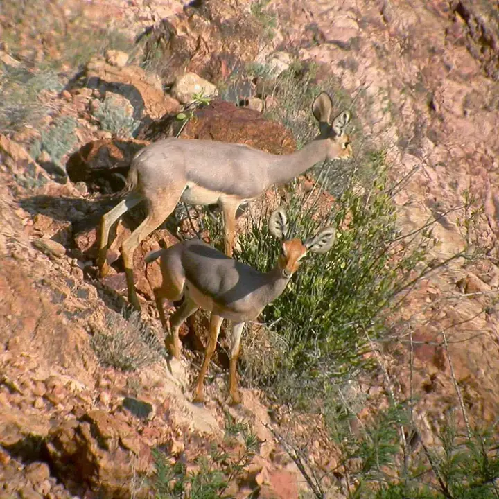
The Dalmar catalogue mentions guest lodges built for visitors in the Forêt du Day sector. Added to those are the camps of the Tadjourah hinterland, including the Dittilou camp, set in a mountain cirque, which serves as a starting base for hikes and where you meet green monkeys, baboons, klipspringers, francolins and Verreaux’s eagles.
Capacities remain small. Book in advance, especially for a weekend in the cool season, and confirm what is included — meals, transfer, sheets, mosquito net — because that is the most frequent source of gap between the announced price and the bill. Also bring cash: electronic payment is rare outside Djibouti City.
When should you visit Bankoualé?
The most comfortable window runs from November to March. That is the period when the heat comes down, on the coast as well as in the mountains.
The rest of the year, the altitude of the massif softens the climate without making it cool: the sector remains more bearable than the coastline in summer, but walking during the day demands the same precautions as elsewhere in the country. The catalogue specifies that the Forêt du Day is accessible all year; that does not mean all seasons are equal for walking.
To set your dates, the page when to go to Djibouti gives the month-by-month detail, and the Tadjourah page covers the rest of the region. If you combine this stay with another site in the hinterland, the Abourma rock engravings lie further north, on the Makarrassou massif.
Frequently asked questions
What is there to see at Bankoualé?
A waterfall that flows in every season, irrigated gardens dominated by palms with fan-shaped leaves, and the village itself, clinging to the foothills of the Goda massif. The sector also offers viewpoints over the Gulf of Tadjourah and the neighbouring villages. It is an oasis landscape: water, greenery and crops, in a mineral environment.
Does the Bankoualé waterfall flow all year?
Yes. The Dalmar catalogue describes it as a waterfall that flows continuously, and the National Tourism Agency specifies that it flows in every season. That is what sets Bankoualé apart from other sites in the hinterland: water there is not a seasonal event, and the gardens it feeds stay green while the surrounding wadis are dry.
Can you hike from Bankoualé to the Forêt du Day?
Yes, and that is in fact the main reason to stop there. The village lies at the foot of the Goda massif, which the Forêt du Day national park covers over thirty square kilometres. Trails leave from the gardens and climb towards the ridges. We publish no distance or duration: they depend on the route chosen and your pace, and it is better to discuss that on site with a local guide.
Where can you stay at Bankoualé?
The catalogue notes guest lodges built for visitors in the sector. Added to those are the camps of the Tadjourah hinterland, including the Dittilou camp, tucked into a mountain cirque. Capacities are small: book in advance, confirm what is included and bring cash, because card payment is rare outside the capital.
What is the best period to visit Bankoualé?
From November to March, when the heat comes down on the coast as well as in the mountains. The altitude of the massif softens the climate the rest of the year, which makes the sector more bearable than the coast in summer, without making it cool. Set off early in the morning: the climb to the ridges is done in the sun, and shade becomes scarce above the gardens.
Sources
Location
Lat. 11.77842Lng. 42.65617
Destinations
Read next
Abourma: the rock engravings of the Makarrassou massif
Ali-Sabieh: the south-east region, sites and camps
Allols depression: salt, hot springs and caravans
Ardoukoba: the most recent volcano in Djibouti
Arta: the cool of the interior and whale sharks
Assamo: the protected area of the beira antelope
Balho: rock art and the northern border post
Daasbiyo cave: rock paintings and burial mounds